Information Taken From The City of North Vancouver ...
Update July 2022
In May 2022, we launched the second phase of engagement for the Upper Levels Greenway and presented three route options based on the priorities you told us were important. We also presented a number of design approaches and gathered input about how well each of the different approaches support the community priorities of safety and experience.Over 800 survey responses were received and over 100 people attended in-person events to share their input. Learn more in the Phase 2 Engagement Summary.The feedback we received indicates that the Purple Route is likely emerging as the preferred option to advance to the next phase of concept design. The public engagement period also helped us identify several technical questions that require further exploration in order to confirm the preferred route. Learn more in the Existing Conditions Summary.Over the next few months, we will explore key feasibility questions related to:
In May 2022, we launched the second phase of engagement for the Upper Levels Greenway and presented three route options based on the priorities you told us were important. We also presented a number of design approaches and gathered input about how well each of the different approaches support the community priorities of safety and experience.Over 800 survey responses were received and over 100 people attended in-person events to share their input. Learn more in the Phase 2 Engagement Summary.The feedback we received indicates that the Purple Route is likely emerging as the preferred option to advance to the next phase of concept design. The public engagement period also helped us identify several technical questions that require further exploration in order to confirm the preferred route. Learn more in the Existing Conditions Summary.Over the next few months, we will explore key feasibility questions related to:
- Alignment options in Tempe Heights Park, including considerations around topography, accessibility, and forest and invasive species management
- The condition of the berm between Lynn Valley Road and Tempe Heights Park
- Intersection analysis and design options for safely crossing both Lonsdale and Westview Drive
- Neighbourhood level traffic calming opportunities to reduce speeding and shortcutting while maintaining local access
Questions and Answers:
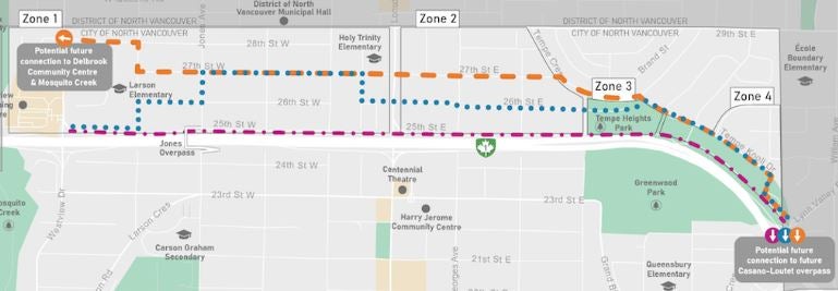
As a follow up to the last question. Where does the Purple route go East of Tempe Park? Where does the orange and blue routes go East of Tempe Park? They both seem to go down Tempe Knoll Dr.
The Purple route continues through the natural space in the park to connect to Lynn Valley Drive.The Blue and Orange routes are both on Tempe Knoll Drive and Wilding Way. They branch near the north edge of Tempe Park with the Blue route travelling through to connect with 26th Street while the Orange travels north along Tempe Crescent to connect to 27th Street.
The Purple route continues through the natural space in the park to connect to Lynn Valley Drive.The Blue and Orange routes are both on Tempe Knoll Drive and Wilding Way. They branch near the north edge of Tempe Park with the Blue route travelling through to connect with 26th Street while the Orange travels north along Tempe Crescent to connect to 27th Street.
How would the blue route work, considering the City sold that portion of West 26th Street to a developer a few years ago? The City must know this. Will this route travel on the private property sold to the developer of the property to the north? Will the owners of the property to the south be consulted? They have not been just like they were not before the City sold a public road to a private developer. Council noted this was a mistake. Are we repeating that? Please provide info on how this route would work, given the road shown on the map no longer exists.
The section of the blue route you’ve commented on contains a City public right-of-way that connects Lonsdale and Western Avenue, which allows people to travel along this proposed route. During this phase of community engagement we’re introducing three general route options, sharing each route’s high level trade-offs and opportunities. Everyone in the neighbourhood is encouraged to provide feedback to help us determine the preferred route and design details
The section of the blue route you’ve commented on contains a City public right-of-way that connects Lonsdale and Western Avenue, which allows people to travel along this proposed route. During this phase of community engagement we’re introducing three general route options, sharing each route’s high level trade-offs and opportunities. Everyone in the neighbourhood is encouraged to provide feedback to help us determine the preferred route and design details
While only roads seem to be in consideration, have laneways been considered as a low impact alternative? Plus, this would help with the liveability of these secondary routes.
Thank you for the suggestion. From the first phase of engagement we heard that the community prioritized Safety, Experience, Connection, and Features. A route that utilizes the laneways could provide a low impact alternative but may not meet many of these objectives. For example, during evenings and darker rainy days, laneways may not provide a pleasant and comfortable experience for most.
Thank you for the suggestion. From the first phase of engagement we heard that the community prioritized Safety, Experience, Connection, and Features. A route that utilizes the laneways could provide a low impact alternative but may not meet many of these objectives. For example, during evenings and darker rainy days, laneways may not provide a pleasant and comfortable experience for most.
Hello do any of the routes propose a pedestrian/ bike bridge over the highway on the east side ( ie that could join greenway route) . Crossing over the highway on the existing sidewalks is so dangerous right now and having a safe way to join the greenway route from below the highway is important. Thank you.
The City is building a new pedestrian and cycling overpass over Highway 1, linking the Loutet and Cedar Village neighbourhoods. The Casano-Loutet overpass will provide an important connection between local communities, a safe transportation route for pedestrians and cyclists, as well as a safe route to school for many local students. In the future, the Upper Levels Greenway will be extended from Lynn Valley Road to connect to the Casano-Loutet Overpass.
The City is building a new pedestrian and cycling overpass over Highway 1, linking the Loutet and Cedar Village neighbourhoods. The Casano-Loutet overpass will provide an important connection between local communities, a safe transportation route for pedestrians and cyclists, as well as a safe route to school for many local students. In the future, the Upper Levels Greenway will be extended from Lynn Valley Road to connect to the Casano-Loutet Overpass.
Re the orange and blue routes between Lonsdale and Jones, what are the impacts on street parking?
The details around route design will be developed through the next phase once a preferred pathway is chosen. Any proposed changes to parking will be addressed through this stage of the process and will be brought back to the community for discussion in our next engagement period.The project team is committed to providing a safe active mobility greenway for people, while also ensuring the neighbourhood access for residents and visitors remains safe and intuitive, while also taking into consideration the parking capacity within the neighbourhood.
The details around route design will be developed through the next phase once a preferred pathway is chosen. Any proposed changes to parking will be addressed through this stage of the process and will be brought back to the community for discussion in our next engagement period.The project team is committed to providing a safe active mobility greenway for people, while also ensuring the neighbourhood access for residents and visitors remains safe and intuitive, while also taking into consideration the parking capacity within the neighbourhood.
Has there been a demand study for this walkway? We are in the midst of a housing crisis and it seems the $6 million could be allocated to more pressing needs
The Upper Levels Greenway fills in a missing gap north of the highway to ensure people have more safe choices for how they move about the City. The Greenway has been identified as a needed investment since 2002. This area has been further confirmed as a needed and important route identified by TransLink through the Transport 2050 Major Bike Network update as well as by the Province through the 2021 Regional Cycling Connections Study. As we continue to invest in housing it is increasingly important that we are providing transportation options that support denser development as we cannot accommodate the transportation demand that comes with needed housing growth through the provision of vehicle transportation options alone.
The Upper Levels Greenway fills in a missing gap north of the highway to ensure people have more safe choices for how they move about the City. The Greenway has been identified as a needed investment since 2002. This area has been further confirmed as a needed and important route identified by TransLink through the Transport 2050 Major Bike Network update as well as by the Province through the 2021 Regional Cycling Connections Study. As we continue to invest in housing it is increasingly important that we are providing transportation options that support denser development as we cannot accommodate the transportation demand that comes with needed housing growth through the provision of vehicle transportation options alone.
If the Greenway goes on 25th between Jones and Mahon, will any parking spaces on 25th street be removed? There is currently just barely enough parking on 25th. The alley is narrow and no room to park any additional vehicles in the alley. (It would cause huge problems for residents of the 300 west block between Jones and Mahon if parking spaces were lost. That would also cause problems for residents on Mahon, on Jones, and on 26th Street if displaced cars had to park on those streets).
Thank you for your question about parking. One of the benefits of the Purple route along 25th Street is that there is a fairly wide street with parking mostly on one side of the street. This provides a fair amount of space to incorporate greenway design features without removing parking. This work includes completion of a parking utilization study in the neighbourhood so we ensure we are right-sizing the parking to align with the demand in the community. We are also working to ensure public space provided for transportation uses is fairly shared between all modes, whether people walk, roll, cycle, or drive.The details of how the greenway will be designed will depend on what is received back from this current engagement. We will have a more complete design with specific information about parking and other features during our next phase of engagement.
Thank you for your question about parking. One of the benefits of the Purple route along 25th Street is that there is a fairly wide street with parking mostly on one side of the street. This provides a fair amount of space to incorporate greenway design features without removing parking. This work includes completion of a parking utilization study in the neighbourhood so we ensure we are right-sizing the parking to align with the demand in the community. We are also working to ensure public space provided for transportation uses is fairly shared between all modes, whether people walk, roll, cycle, or drive.The details of how the greenway will be designed will depend on what is received back from this current engagement. We will have a more complete design with specific information about parking and other features during our next phase of engagement.
Why are you pursing this option that is more traffic heavy and has more hills and is not that friendly to bike traffic. The district is proposing a bike route through Kirkstone with a bridge connection to the easy Boulevard neighborhood. This would help school children commenting from lynn valley to Sunderland. It has less traffic and is safer with more green space to ride in. How come the city is not looking at this as a feasible option
Thank you for your question about the broader mobility network. The City is in ongoing conversations with the District about how our mobility networks connect together across boundaries. The area south of Lynn Valley Road will be served by the future Casano-Loutet Overpass that will provide safe connections over the highway and around the schools as you suggested. The overpass will help fill the need for another pedestrian and cycle connection over the highway. The end of the Upper Levels Greenway provides a connection point into the District. This connection through the District falls within their jurisdiction to lead.You can learn more about the Casano-Loutet project here https://www.cnv.org/property-and-development/projects-and-developments/major-studies-and-projects/casano-loutet-overpassFor options north of the highway and west of Lynn Valley Road, the City is leading this discussion around the Upper Levels Greenway. This will further extend safe route options to Westview Drive which will further expand of protected and accessible walking and cycling pathways, providing connections to other schools in the area.The City and District continue to collaborate where our borders intersect to ensure our project priorities are supporting a safe and healthy transportation network for all residents on the North Shore.
Thank you for your question about the broader mobility network. The City is in ongoing conversations with the District about how our mobility networks connect together across boundaries. The area south of Lynn Valley Road will be served by the future Casano-Loutet Overpass that will provide safe connections over the highway and around the schools as you suggested. The overpass will help fill the need for another pedestrian and cycle connection over the highway. The end of the Upper Levels Greenway provides a connection point into the District. This connection through the District falls within their jurisdiction to lead.You can learn more about the Casano-Loutet project here https://www.cnv.org/property-and-development/projects-and-developments/major-studies-and-projects/casano-loutet-overpassFor options north of the highway and west of Lynn Valley Road, the City is leading this discussion around the Upper Levels Greenway. This will further extend safe route options to Westview Drive which will further expand of protected and accessible walking and cycling pathways, providing connections to other schools in the area.The City and District continue to collaborate where our borders intersect to ensure our project priorities are supporting a safe and healthy transportation network for all residents on the North Shore.
The three routes on the map seem to indicate three different Lonsdale crossings. The only traffic light currently is at 27th and Lonsdale. Is the City considering putting another controlled crossing at either 25 or 26th? Thanks Kevin Smith
Thank you for your question. Each of the potential crossings of Lonsdale would require careful design attention to ensure we are implementing a safe crossing that works for all modes. We will be working with the Province on design solutions in this area if we need to add in a new bike/walk crossing at 26th and/or to improve the crossing at 25th in relation to the highway interchange. More detail on crossings will be worked through once we have determined which pathway the greenway will take across Lonsdale.
Thank you for your question. Each of the potential crossings of Lonsdale would require careful design attention to ensure we are implementing a safe crossing that works for all modes. We will be working with the Province on design solutions in this area if we need to add in a new bike/walk crossing at 26th and/or to improve the crossing at 25th in relation to the highway interchange. More detail on crossings will be worked through once we have determined which pathway the greenway will take across Lonsdale.
Having just filled in the questionnaire, I was disappointed that the final questions ask about ethnicity and household income. I know there was an option to not answer but it seems both intrusive and irrelevant that you ask these questions at all.
Thank you for your feedback. The City is committed to improving our engagement activities to reach a diverse segment of our population. All demographic information is collected confidentially and is not tied to individual responses. The City utilizes these responses to evolve our engagement activities on projects to improve our outreach. This initiative is part of Council's direction to improve Diversity, Equity and Inclusion across City projects and programs.
Thank you for your feedback. The City is committed to improving our engagement activities to reach a diverse segment of our population. All demographic information is collected confidentially and is not tied to individual responses. The City utilizes these responses to evolve our engagement activities on projects to improve our outreach. This initiative is part of Council's direction to improve Diversity, Equity and Inclusion across City projects and programs.
How will this impact on street parking for households affected?
The design of the greenway will vary depending on which zone it is travelling through, including the street constraints and spatial requirements to achieve a safe design in each context. Once a route is selected we will be further designing the details, including any proposed changes to parking, and will be engaging with the community further on that initial design in the months to come. The project team is also collecting parking data from the neighbourhood to ensure that there is sufficient access to parking in the community.
The design of the greenway will vary depending on which zone it is travelling through, including the street constraints and spatial requirements to achieve a safe design in each context. Once a route is selected we will be further designing the details, including any proposed changes to parking, and will be engaging with the community further on that initial design in the months to come. The project team is also collecting parking data from the neighbourhood to ensure that there is sufficient access to parking in the community.
Hi there, I'm just reading about the upper level green way. My family lives just above there and we use it to walk to Suterland for sports and also use that park for recreation. Is there any new or different noise barrier fences that can be adopted? The highway noise Is extremely loud and that current fence has loads of holes and isn't high enough to block noise.
Thank you for your feedback. We will consider this request as we advance through the design process and collaborate with our partners at the Ministry of Transportation and Infrastructure.
Thank you for your feedback. We will consider this request as we advance through the design process and collaborate with our partners at the Ministry of Transportation and Infrastructure.
Why is an upper levels greenway needed? Why not use 29th Street which is an easy cross road, and by doing that you'd reduce the heavy traffic flow of people not using Hwy1.
The Upper Levels Greenway is one element of the evolving City and North Shore active mobility network. The greenway project will provide closer access and more direct connections to safe north-south crossing points of the highway. The project is also an opportunity to provide more investment in park and green space in these neighbourhoods. The City aims to meet a range of transportation, safety, accessibility, and parks goals beyond what utilizing the existing transportation focused infrastructure on 29th Street allows for.
The Upper Levels Greenway is one element of the evolving City and North Shore active mobility network. The greenway project will provide closer access and more direct connections to safe north-south crossing points of the highway. The project is also an opportunity to provide more investment in park and green space in these neighbourhoods. The City aims to meet a range of transportation, safety, accessibility, and parks goals beyond what utilizing the existing transportation focused infrastructure on 29th Street allows for.
Would this project affect our parking areas on the street at 27 th st W
In order to provide safe and accessible mobility space there may need to be adjustments to how parking is designed and accommodated. This would be something the design process will examine regardless of where the greenway travels. Various considerations such as the width of the street, parking demand, and safety requirements will inform how these elements will be integrated together.
In order to provide safe and accessible mobility space there may need to be adjustments to how parking is designed and accommodated. This would be something the design process will examine regardless of where the greenway travels. Various considerations such as the width of the street, parking demand, and safety requirements will inform how these elements will be integrated together.
Why are you squeezing a bike lane on 27 th street?? It doesn’t make sense it’s the narrowest road above the highway. Wouldn’t 26,25 th be a Better solution as these roads are wider plus these have extra wide sidewalks?? Who comes up with these ridiculous decisions! Obviously people who don’t live on that street others wise this wouldn’t even be an option. You have done everything in the book in regards to moody street. Speed bumps, stop signs in ever intersection. Why not on 27th. We have two schools. One at the beginning and one at the end of 27 th street. Make it a walking only zone. Except for people who live on the street who are considered about all the young children living on our street. Can you find a better solution than making our street even smaller than it is?
Thank you for your feedback on the 27th Street sections of the various routes. The purpose of this engagement period is to gather input on the options so we can inform a route that will work for the community. No decision has been made about where the greenway will travel yet. This is one of the initial options because it helps provide direct links to the schools in the area and there is interest in providing safe travel options to these destinations. We have also received feedback requesting traffic calming and sidewalk improvements throughout the neighbourhood, including 27th Street. These improvements will still be considered even if the official greenway route travels along a different street.The Upper Levels Greenway is more than a bike lane project. It is a full active mobility project looking at all the safety, accessibility, and connection opportunities for people of all ages travelling by all modes.
Thank you for your feedback on the 27th Street sections of the various routes. The purpose of this engagement period is to gather input on the options so we can inform a route that will work for the community. No decision has been made about where the greenway will travel yet. This is one of the initial options because it helps provide direct links to the schools in the area and there is interest in providing safe travel options to these destinations. We have also received feedback requesting traffic calming and sidewalk improvements throughout the neighbourhood, including 27th Street. These improvements will still be considered even if the official greenway route travels along a different street.The Upper Levels Greenway is more than a bike lane project. It is a full active mobility project looking at all the safety, accessibility, and connection opportunities for people of all ages travelling by all modes.
Is 27th st W could be a first choice route of this project? How about 25th or 26 th st those streets have a wider street and less demands for parking? When would be the project begin?
As noted in the survey materials, there is no clear "best" option for the Upper Levels Greenway route. The feedback received during this round of engagement will help us select the preferred route and begin developing the design for the corridor.The construction schedule for the project is not yet confirmed and will depend on the complexity and cost of the final design. The goal is to have a design for the project for early 2023 to inform construction decisions.
I just reviewed the various questions and answers below. When residents asked about loss of parking you mentioned parking surveys. The last time you did parking surveys for the 29th bike route, the surveys were conducted during the day. When you do a parking survey I would hope you would do it after 8pm when most people are at home so you see how little parking there is. Many houses have basement suites. There are often 3 cars parked per house. Not to mention the new condos on Lonsdale and 5 new homes on 28th. Parking is becoming an issue. Losing parking would be devastating and wrong. There are young families and seniors in this neighborhood they need to be able to park in front of their homes.
Thank you for the feedback on previous parking studies. We have conducted counts through 6 different time periods, including capturing overnight parking use. These details will be available as we report out on the analysis through the process.
Thank you for the feedback on previous parking studies. We have conducted counts through 6 different time periods, including capturing overnight parking use. These details will be available as we report out on the analysis through the process.
We live in the area and did not hear about the project until we received the mailing in the first week of May 2022. Also, could you please confirm that an introductory meeting was held on May 10/22 at Larson elementary? How did you advise the residents from the area? Are you planning to hold additional meetings for the residents?
The City mailed postcards to every residential and commercial address in the neighbourhoods north of the highway. Signs have been placed throughout the community targeting people both walking, cycling, and driving and we have been handing out postcards on the street a various points in time through this engagement period. We are regularly sending out information through our CityView newsletter and on our various social media channels. You can sign up for the CityView newsletter at https://www.cnv.org/your-government/news-room/city-view-e-newsletter-subscription(External link)We hosted the Open House at Larson school from 3-8pm on May 10. We also hosted a table at CityFest on May 7 from 11am-3pm. On May 14, from 11am-1pm, we will be setting up a pop-up tent on Grand Boulevard. You are welcome to come by and discuss the project with us there.You can see a record of how we engaged with the community in February in the Phase 1 Engagement Summary Report listed on the right sidebar of Let's Talk.By completing the survey here on Let's Talk you will also be included in all future email communications as the project moves through the process.
I would like to know the reason for the Blue route jogging one block north to 27th Street at Jones Avenue instead of continuing along 26th for those few blocks. In my experience (I have owned a home in the area since 1985) 26th is a much quieter street for vehicle traffic.
Thank you for the suggestion. Part of the challenge with the 26th Street section west of Lonsdale is one of the blocks does not connect through. The blue route was shown to go north to connect with Holy Trinity at this location to serve the school and get around the disconnected block. All feedback of this nature will be used to inform how the final route is assembled.
Why do all of the routes end on the same small patch of Lynn Valley Road? If the idea is to connect to the Casano-Loutet overpass then it requires crossing Lynn Valley Road - the options for crossing there are terrible and unsafe (another pedestrian was hit by a car trying to cross Lynn Valley Road here recently). Crossing LV Rd requires crossing the highway on-ramp first negating any reason people would have to go to the overpass. If the City and District are going to change the crossing then that project will be WAY more controversial than any greenway route and should be decided first (since this is a traffic chokepoint for t the whole of Lynn Valley) .
Thank you for your suggestion and desire to see safety improvements in this location. The Lynn Valley Road intersection is under review by the Province to complete safety and operational improvements. The City project team is in communication with our colleagues in the District about how a pathway will navigate District land toward the new Casano-Loutet Overpass. These improvements will be complementary parallel works separate from this greenway design process
Will you be installing at least one sidewalk on St. Georges and St Andrews from 29th down to 25th for safety? Many cars uWalking access north of Hwy 1 to the new Rec Centre, shopping and City Hall area south of Hwy 1 really needs to improve safety. Connecting to NVD bike path on 29th over a new overpass to the Green Necklace would be great to provide a safe route over Hwy 1.....Please!!!
Thank you for your suggestions. This project will be considering opportunities for sidewalk infill throughout the neighbourhoods to improve connections in and around the main greenway route and to surrounding destinations.The City is in ongoing conversations with the Province about opportunities for an additional highway overpass east of Lonsdale. The greenway route selected will not preclude a tie in to another overpass if that separate project advances. The City will be looking to improve connections to the Jones overpass and is in discussion with the District of North Vancouver about making a connection to the new Casano-Loutet overpass that will begin construction soon. You can learn more about that new overpass project here https://www.cnv.org/property-and-development/projects-and-developments/major-studies-and-projects/casano-loutet-overpass
If one of the stated goals of the project is “an opportunity to link existing parks and open spaces with schools, commercial areas, amenities, and destinations” then why do all the available routes avoid going anywhere near Boundary School, or in the direction of Argyle? These are the catchment elementary and high schools for half of the area the proposed greenway is supposed to serve. Providing safe rolling access to school for students would also reduce traffic in the area and improve the experience of all local residents. Why is there no connection to the separated bike path along 29th that leads to Lynn Valley Centre and part way to Argyle School? It seems that since the destinations lie in the District of North Vancouver instead of the city they have been overlooked, but these are important destinations for most City residents north of the highway.
If one of the stated goals of the project is “an opportunity to link existing parks and open spaces with schools, commercial areas, amenities, and destinations” then why do all the available routes avoid going anywhere near Boundary School, or in the direction of Argyle? These are the catchment elementary and high schools for half of the area the proposed greenway is supposed to serve. Providing safe rolling access to school for students would also reduce traffic in the area and improve the experience of all local residents. Why is there no connection to the separated bike path along 29th that leads to Lynn Valley Centre and part way to Argyle School? It seems that since the destinations lie in the District of North Vancouver instead of the city they have been overlooked, but these are important destinations for most City residents north of the highway.
The City project team is in communication with our colleagues at the District regarding how our active mobility networks can integrate with and complement each other. This greenway work is focused on routes south of the CNV/DNV boundary to infill the mobility network in these neighbourhoods that are missing key infrastructure such as sidewalks and safe cycle routes.The Upper Levels Greenway project will be considering additional opportunities for improved north south connections in key locations. Your comment about a clear connection to the 29th Street route has been noted as one of these considerations